上海航天, 2024, 41 (3): 25, 网络出版: 2024-09-03
透视空天红外遥感探测技术:演进规律与发展趋势  下载: 1189次
Peering into Aerospace Infrared Remote Sensing Detection Technology:Evolutionary Patterns and Development Trends
图 & 表
图 1. 风云气象卫星观测网[图中,FY 是风云气象卫星的拼音缩写,FY-4A 指的是风云四号A 星,其他的风云气象卫星缩写规律相同。对地静止环境工作卫星(Geostationary Operational Environmental Satellite ,GOES ),极轨环境卫星(Polar Orbit Environment Satellite ,POES ),气象卫星(Meteorological Satellite ,Meteosat ),气象业务和气候监测卫星(Meteorological Operational Satellite Program ,Metop ),向日葵气象卫星(Himawari ),先进的陆地观测卫星(Advanced Land Observing Satellite ,ALOS )]
Fig. 1. Observation network of Fengyun meteorological satellites (In the figure ,FY is the abbreviation for Fengyun meteorological satellite.FY-4A refers to Fengyun-4A satellite ,and the abbreviation rule is the same for other Fengyun meteorological satellites.Geostationary Operational Environmental Satellite (GOES ),Polar Orbit Environment Satellite (POES ),Meteorological Satellite (Meteosat ),Meteorological Operational Satellite Program (Metop ),Himawari meteorological satellite (Himawari ),and Advanced Land Observing Satellite (ALOS ))
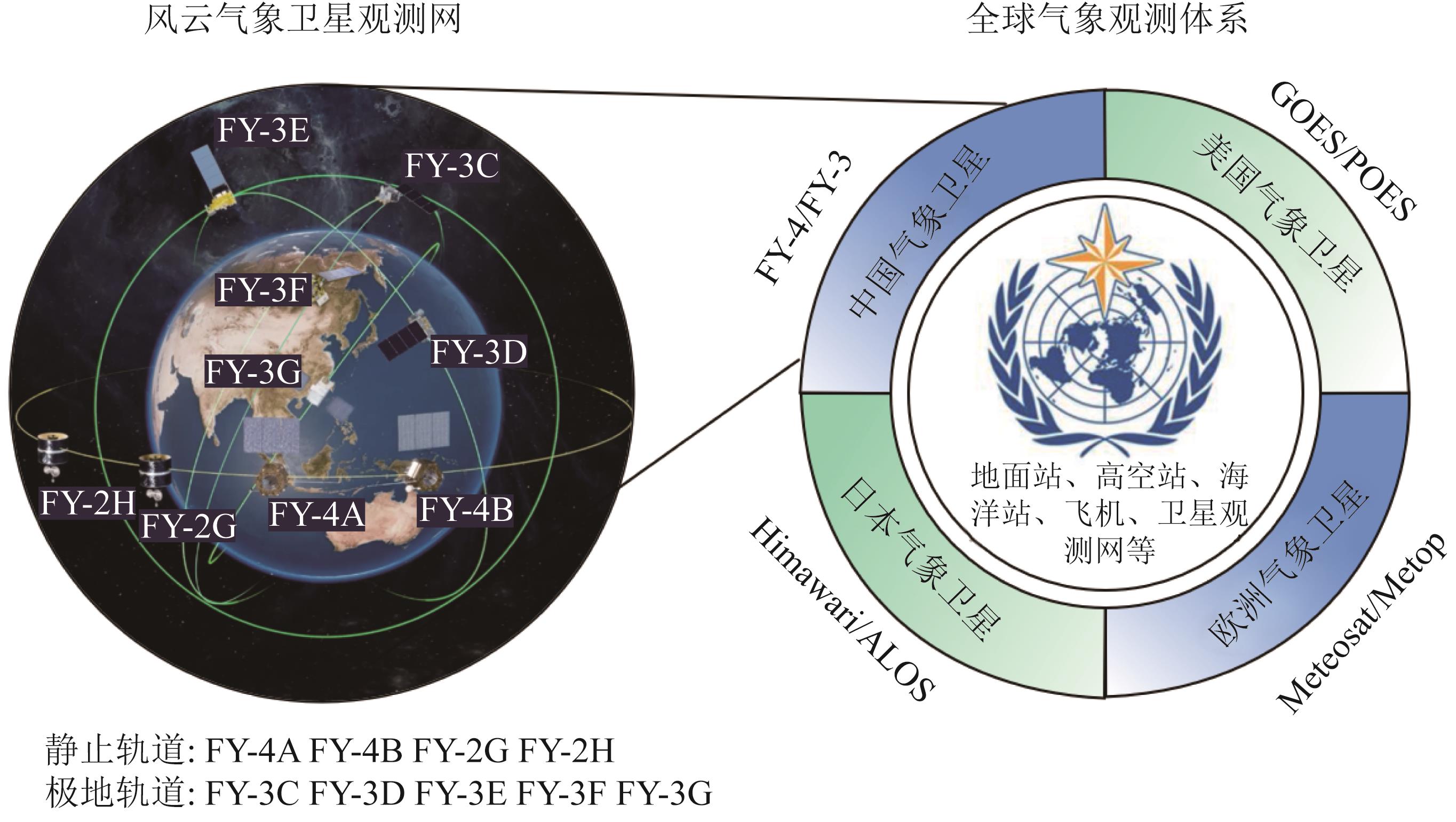
图 2. 风云气象卫星的技术演进路线图[图中,虚拟现实(Virtual Reality ,VR ),增强现实(Augmented Reality ,AR ),混合现实(Mixed Reality ,MR ),人工智能(Artificial Intelligence ,AI )]
Fig. 2. Technical evolution roadmap of Fengyun meteorological satellites (In the figure ,there are Virtual Reality (VR ),Augmented Reality (AR ),Mixed Reality (MR ),and Artificial Intelligence (AI ))
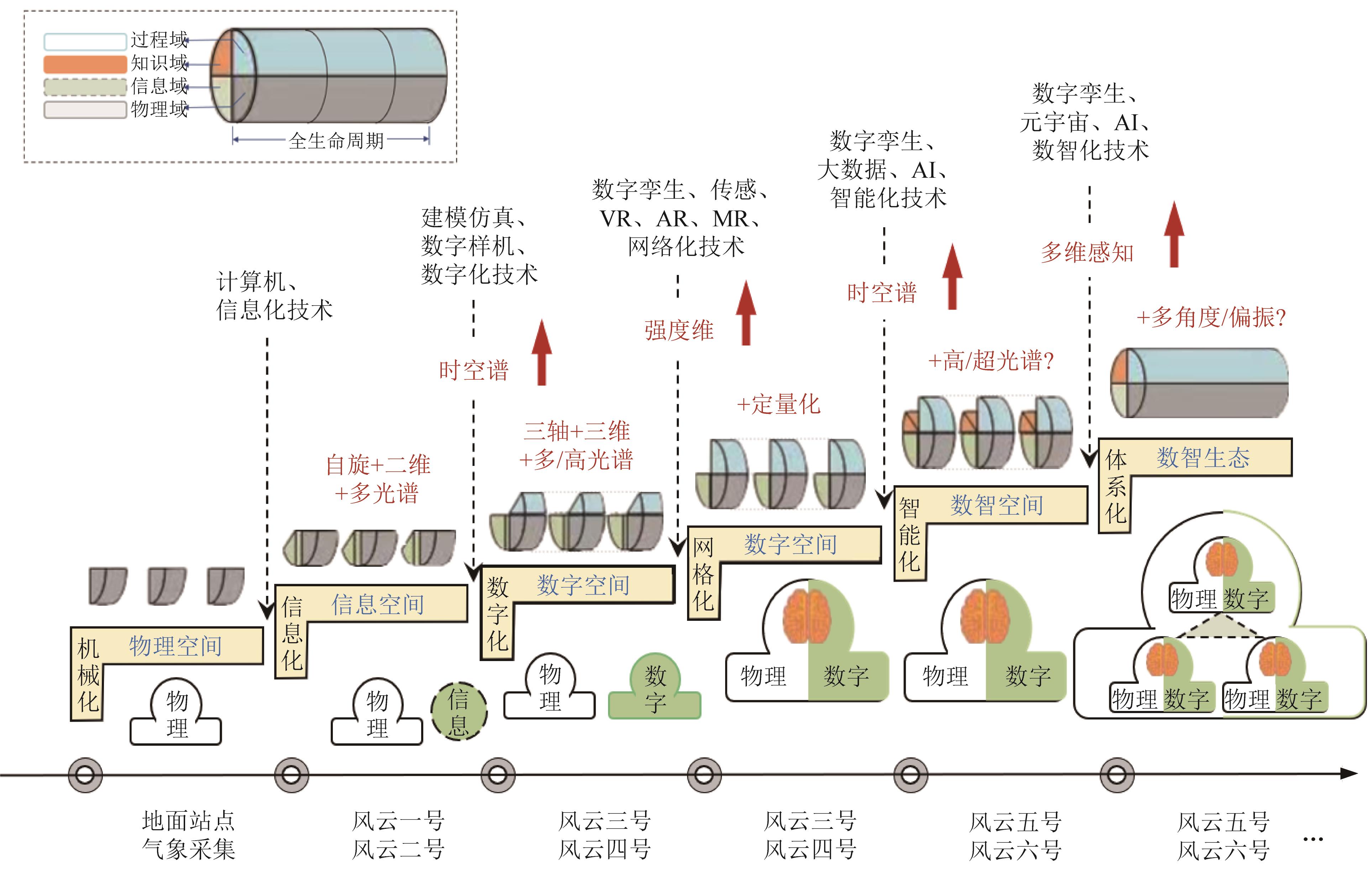
图 3. 红外遥感技术能力的制约
Fig. 3. Constraint diagram of the capability of infrared remote sensing technology
图 4. 红外高光谱遥感技术的演进[图中,航空成像光谱仪一号(Aviation Imaging Spectrometer-1 ,AIS-1 ),机载可见光近红外成像光谱仪(Airborne Visible/InfraRed Imaging Spectrometer ,AVIRIS ),地球观测1 号卫星/ 高光谱成像光谱仪(Earth Observing-1/Hyperion ,EO-1/ Hyperion ),紧凑型高分辨率成像光谱仪(Compact High Resolution Imaging Spectrometer ,CHRIS ),环境一号卫星A 星(HJ-1-A ),天宫一号(TG-1 ),地球传感成像光谱仪(DLR Earth Sensing Imaging Spctrometer ,DESIS ),环境制图仪(Environmental Mapping ,EnMAP ),高分五号卫星/ 先进高光谱成像仪(Gaofen-5/Advanced Hyperspectral Imager ,GF-5/AHSI ),资源一号02E 星(ZY-1-02E )]
Fig. 4. Evolution diagram of the infrared hyperspectral remote sensing technology (In the figure ,Aviation Imaging Spectrometer (AIS-1 ),Airborne Visible/InfraRed Imaging Spectrometer (AVIRIS ),Earth Observing-1/Hyperion Imaging Spectrometer (EO-1/Hyperion ),Compact High Resolution Imaging Spectrometer (CHRIS ),Environmental Satellite-1A (HJ-1-A ),Tiangong-1 (TG-1 ),DLR Earth Sensing Imaging Spectrometer (DESIS ),Environmental Mapping Spectrometer (EnMAP ),Gaofen-5/Advanced Hyperspectral Imager (GF-5/AHSI ),and Ziyuan-1 02E Satellite (ZY-1-02E ))
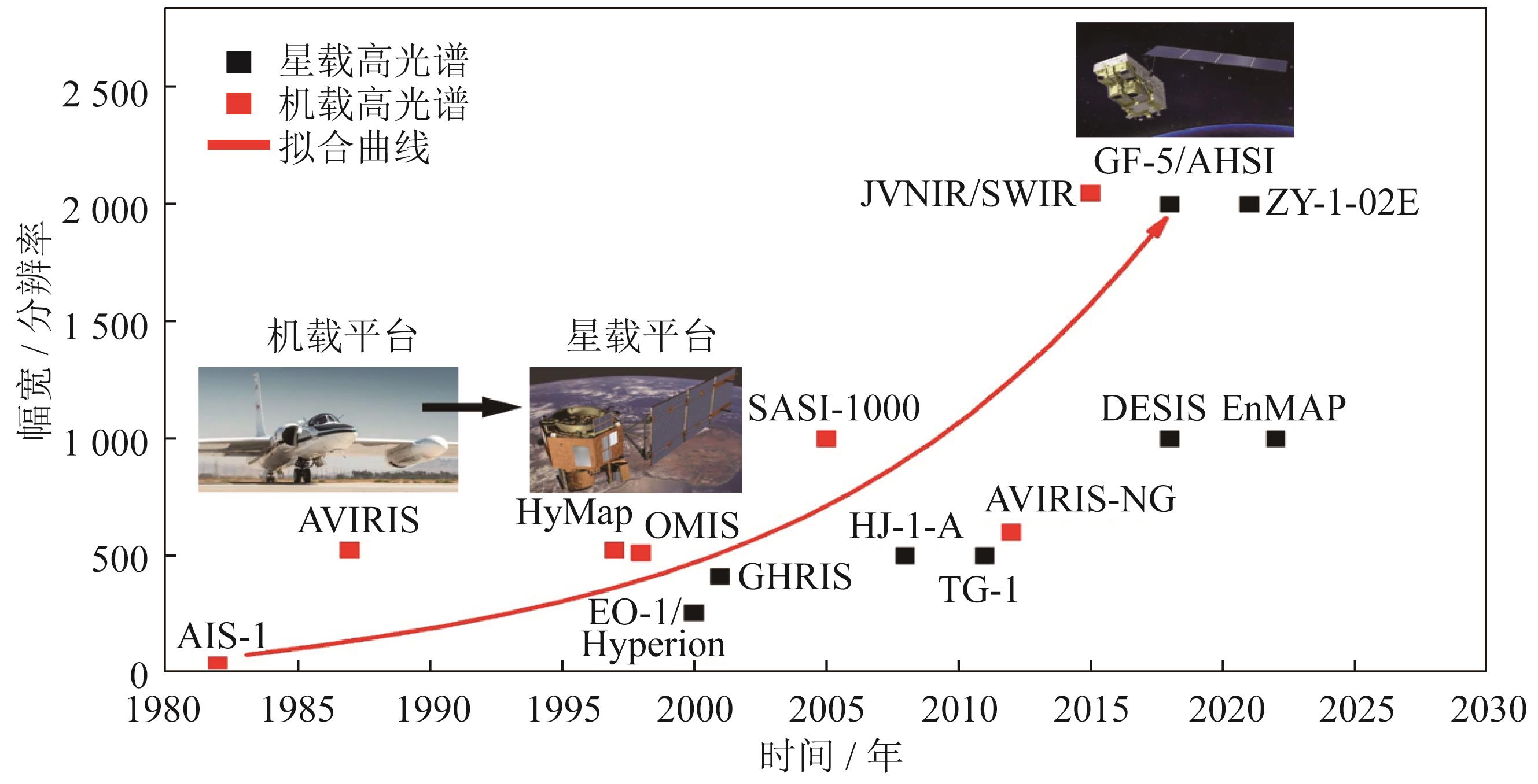
图 5. 星载热红外遥感技术的演进[图中,甚高分辨率辐射仪(Very High Resolution Radiometer ,VHRR ),高级甚高分辨率辐射仪(Advanced Very High Resolution Radiometer ,AVHRR ),中分辨率成像光谱仪(Moderate-Resolution Imaging Spectroradiometer ,MODIS ),陆地卫星7 号增强型专题绘图仪(Landsat 7 Enhanced Thematic Mapper Plus ,L7/ETM+ ),风云三号A 星可见光和红外辐射仪(Visible and Infrared Radiometer ,VIRR ),陆地卫星8 号热红外传感器(Landsat 8 Thermal Infrared Sensor ,L8/TIRS ),美国国家海洋和大气管理局20 号卫星/ 可见光红外成像辐射仪套件(NOAA-20 Visible Infrared Imaging Radiometer Suite ,NOAA-20/VIIRS ),高分五号卫星/ 可见光和红外多光谱成像仪(GF-5 Visible and Infrared Multispectral Imager ,GF-5/VIMI ),环境二号卫星A 星/ 红外光谱仪(HJ-2A Infrared Spectrometer ,HJ-2A/IRS ),可持续发展科学卫星1 号热红外成像仪(SDGSAT-1 Thermal Infrared Sensor ,SDGSAT-1/TIS )]
Fig. 5. Evolution diagram of the spaceborne thermal infrared remote sensing technology (In the figure ,Very High Resolution Radiometer (VHRR ),Advanced Very High Resolution Radiometer (AVHRR ),Moderate-Resolution Imaging Spectroradiometer (MODIS ),Landsat 7 Enhanced Thematic Mapper Plus (L7/ETM+ ),Fengyun-3A Visible and Infrared Radiometer (VIRR ),Landsat 8 Thermal Infrared Sensor (L8/TIRS ),NOAA-20 Visible Infrared Imaging Radiometer Suite (NOAA-20/VIIRS ),GF-5 Visible and Infrared Multispectral Imager (GF-5/VIMI ),HJ-2A Infrared Spectrometer (HJ-2A/IRS ),and SDGSAT-1 Thermal Infrared Sensor (SDGSAT-1/TIS ))
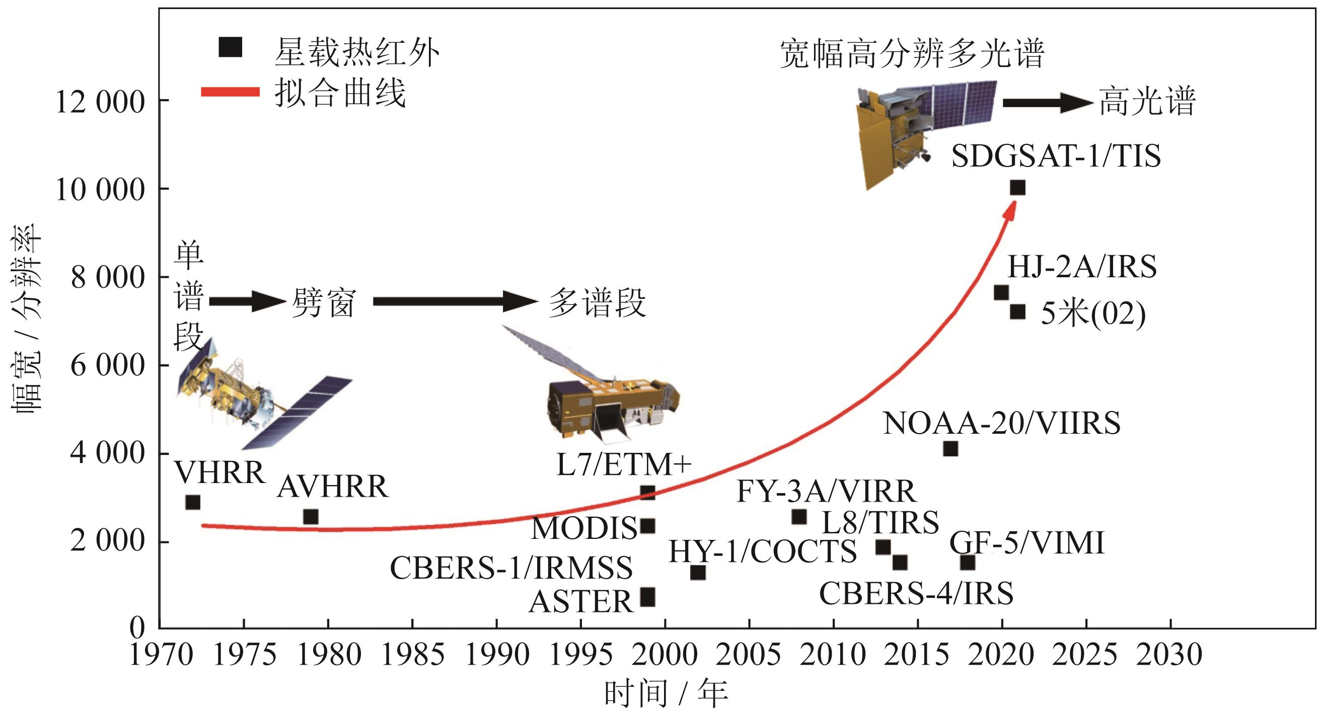
图 7. 仿生学的感存算一体化智能感知技术
Fig. 7. Diagram of the perception ,storage ,and computation-integrated intelligent sensing technology based on bionics
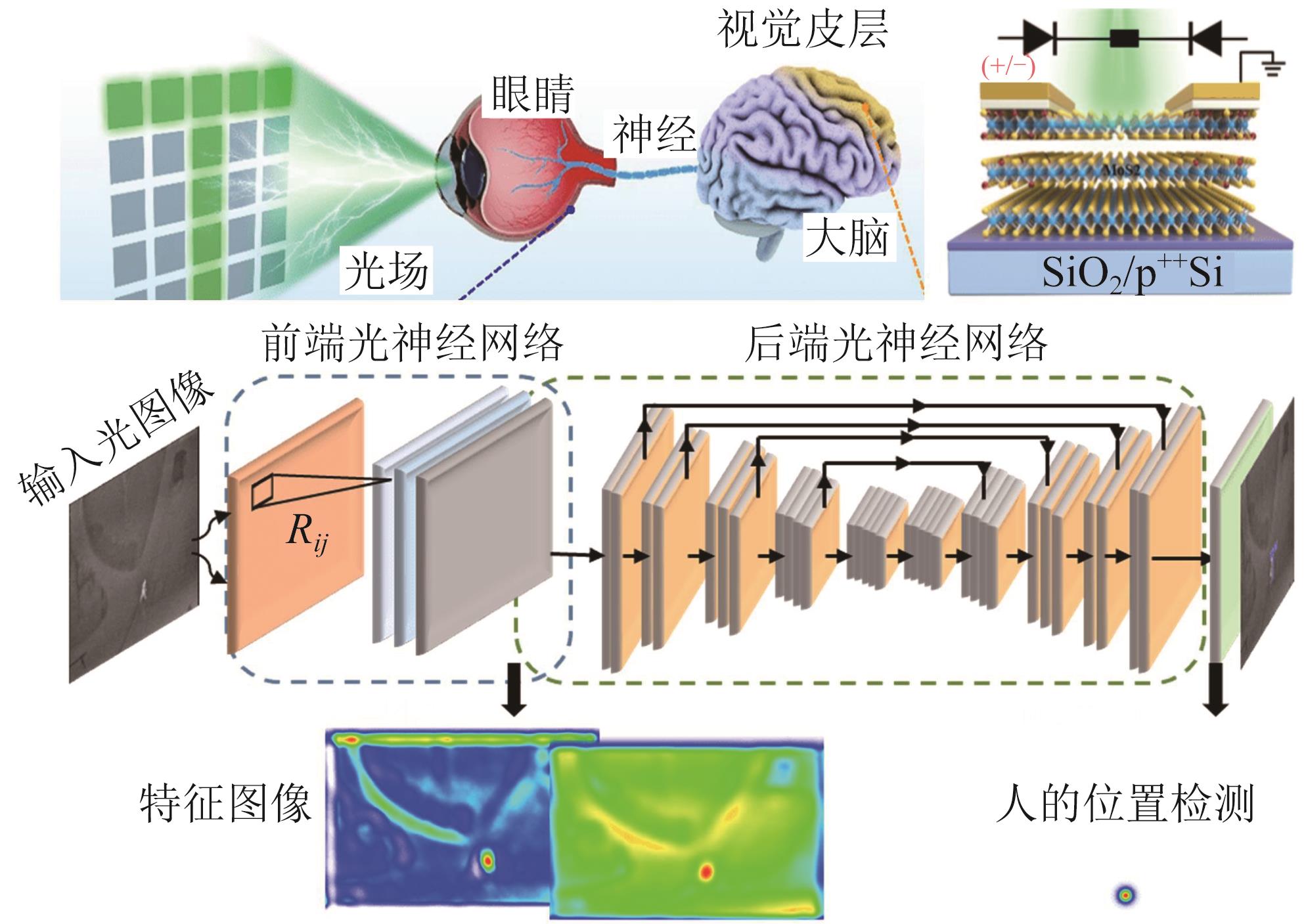
图 8. 新时代背景下的卫星智造和遥感应用
Fig. 8. Intelligent manufacturing and remote sensing applications of satellites in the new era
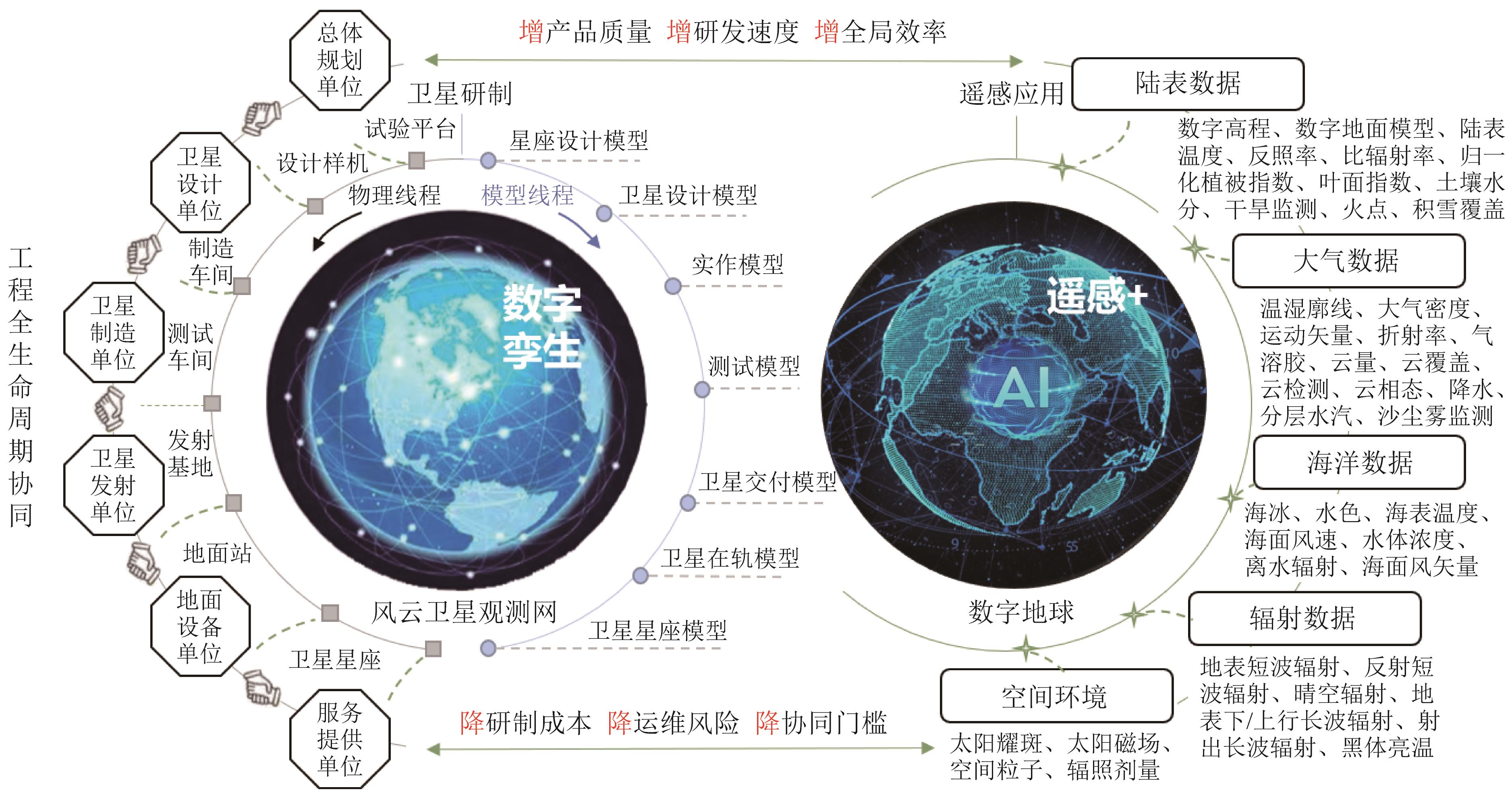
图 9. 红外目标检测算法或模型的发展历程[图中的缩写算法名称分别是,卷积神经网络(Convolutional Neural Network ,CNN ),快速的基于区域的卷积神经网络(Fast Region-based Convolutional Neural Network ,Fast R-CNN ),你只需看一次算法(You Only Look Once ,YOLO ),你只需看一次版本8 ,(You Only Look Once version 8 ,YOLOv8 ),基于区域的卷积神经网络(Region-based Convolutional Neural Network ,R-CNN ),单步多框检测器(Single Shot MultiBox Detector ,SSD )]
Fig. 9. Development history of infrared target detection algorithms or models (The abbreviated algorithm names in the figure are as follows :Convolutional Neural Network (CNN ),Fast Region-based Convolutional Neural Network (Fast R-CNN ),You Only Look Once (YOLO ),You Only Look Once version 8 (YOLOv8 ),Region-based Convolutional Neural Network (R-CNN ),and Single Shot MultiBox Detector (SSD ))
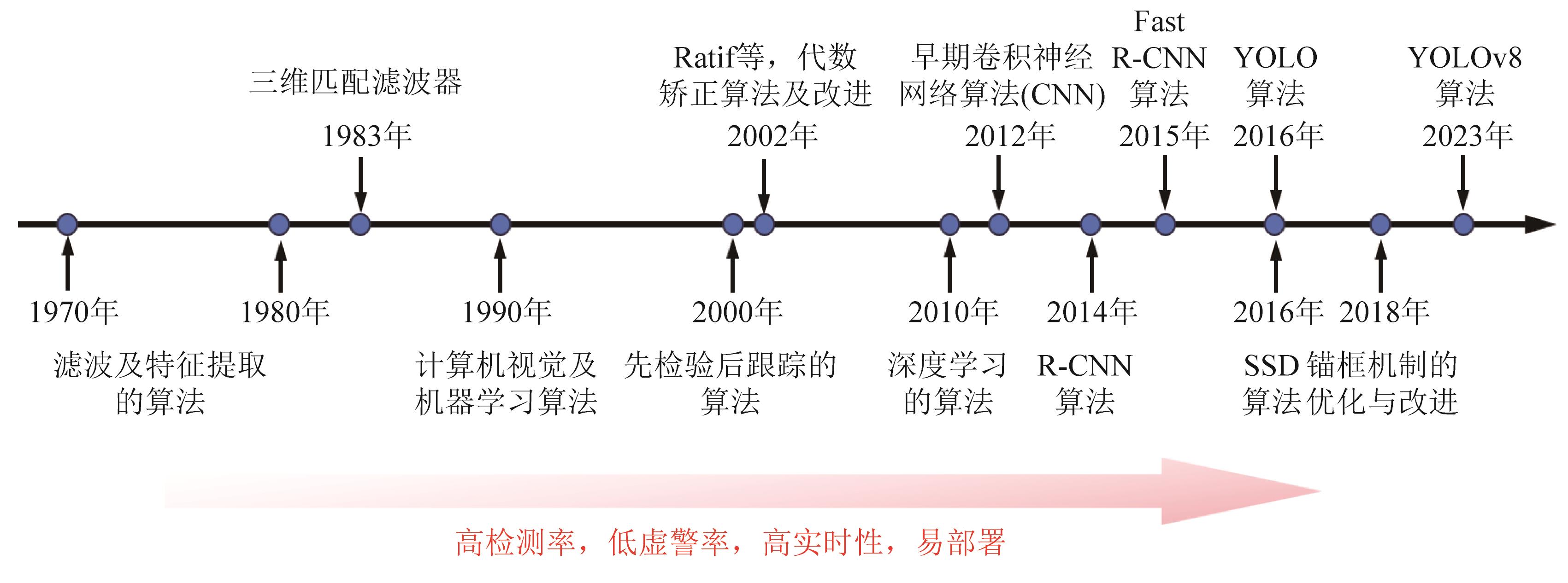
表 1风云气象卫星的发展时间线
Table1. Development timeline of Fengyun meteorological satellites
|
表 2短波红外碲镉汞探测器的主要技术指标
Table2. Main technical specifications of the shortwave infrared mercury cadmium telluride detectors
|
李亚冉, 保昊辰, 孙胜利. 透视空天红外遥感探测技术:演进规律与发展趋势[J]. 上海航天, 2024, 41(3): 25. Yaran LI, Haochen BAO, Shengli SUN. Peering into Aerospace Infrared Remote Sensing Detection Technology:Evolutionary Patterns and Development Trends[J]. AEROSPACE SHANGHAI, 2024, 41(3): 25.


 PDF全文
PDF全文